
Most people probably know that it is important to know where you are and what time it is where you are or where you are going for long-distance sailing. However, not everyone is thinking about the fact that there are several ways to indicate a position on earth or to indicate the time. Different maps can be based on different position systems and be produced with different so-called projections (how the curved surface of the earth is shown on a flat map), which may not be general knowledge either. In this article, I will describe what we as long-distance sailors need to know in this context.

To know where you are, you need a position, but a position on earth can be indicated in many different ways. The same thing with time, it can be specified in several different ways. This applies, among other things, to weather reports, tide diagrams, emergency reporting and position indications of moving objects, etc. In order for everyone in shipping to be able to communicate position and time correctly, certain standards for time and position are used.
Position at sea
On a modern chart, the position is given as latitude and longitude according to a standard for position indication on the earth’s surface called WGS-84 . That standard is also used by the GPS system . This makes the position displayed by the GPS easy to transfer to a chart.
Latitude refers to 0 to 90 degrees north (N) or south (S) of the equator, and longitude refers to 0 to 180 degrees west (W ) or east (E) of the 0 meridians passing through Greenwich in England.
When writing a position, the degrees always stand for latitude first (north/south) and then longitude (west/east).
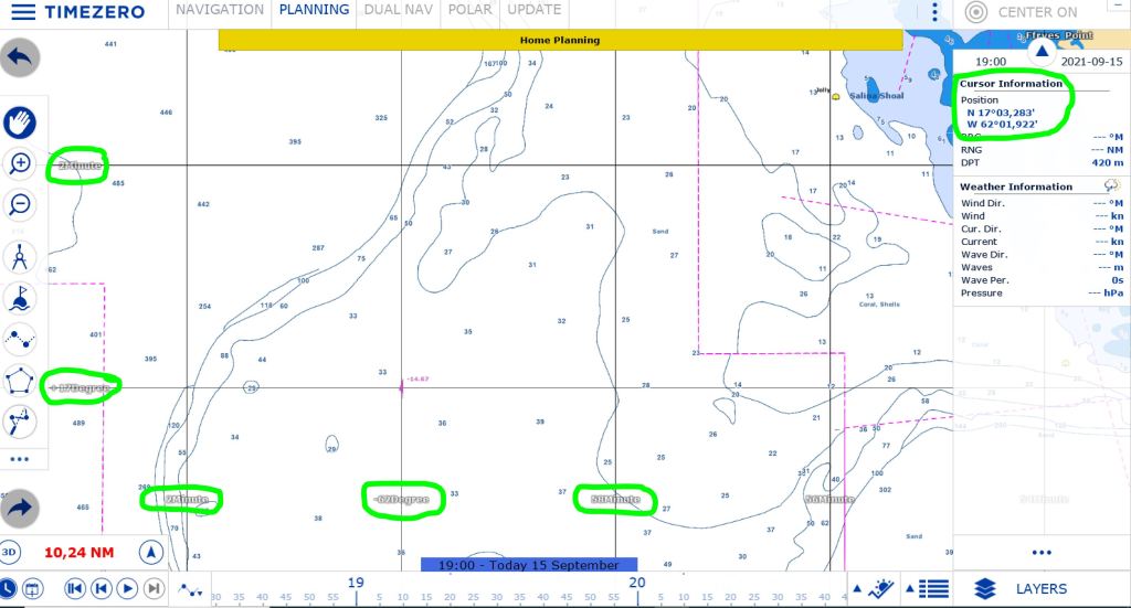
On charts, degrees are given as whole degrees and decimal minutes (DM.m) and this means that we have set our plotter to show degrees in the same way. Whole degrees have a value of 0 to 180, while minutes can have a value of 0.00 to 59.99. There is 60 minutes on a degree, why not show 60? This is because when the value becomes 60, the degree is increased by one by the plotter and the minutes are zeroed.
Online mapping services often use decimal degrees (D.d), ie 0.0000000 to 180.00000 degrees
Latitude and longitude can be written with the letter of latitude before or after the degrees.
This allows a position to be written in several different ways and still refer to the same position, see examples below of different ways to write the same position.
As degrees and decimal minutes
- N40°6,4′ E5°12,8′
- 40°6,4’N 5°12,8’E (as we write this)
As decimal degrees
- N40,104° E5,208°
- 40,104°N 5,208°E
Position on a chart
On a chart and on our plotter, latitude and longitude are indicated by degrees and minutes. This means that the position is specified with degrees and decimal minutes. If we get a position specified in decimal degrees (D.d) and need to enter it on the chart, we need to convert it to decimal minutes (DM.m). We do this with a simple formula that multiplies the decimal part (d) of D.d by 60. The integer part of the degree is the same in both cases.
The image below shows how a charting program on a PC can display a position. On the one hand, there are degree and minute indications of latitudes and longitudes. You use the cursor to draw a position on the map. A paper chart also has the degree and minute markings on the edge, but there you use a divider and a ruler to get or mark a position on the map.
Time at sea
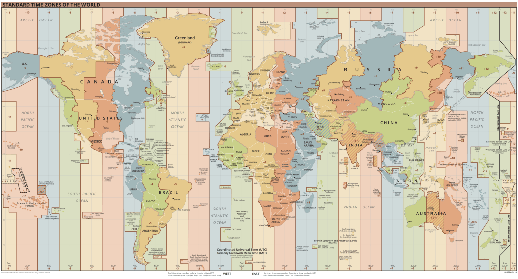
UTC (Universal Time Coordinated) is the standard used for all civilian time today, even in shipping. The time in UTC is based on International Atomic Time (TAI). UTC also defines time zones to produce a local time for each place on earth.
Time zones
In addition to the time zone around the 0-meridian (UTC±0, usually this time zone is written as UTC), the UTC standard defines 12 time zones to the east and 12 zones to the west. Time zones east of the UTC±0 zone are written as UTC+1, UTC+2, etc. The reason is that in these zones the clock is more than at the UTC±0 (the sun rises in the east and the clock has time to rise 1 hour before the sun rises in the next time zone to the west, which means that the time zones west of the 0-meridian are written as UTC-1, UTC-2, etc.
If a time says 13:30 UTC±0, the time is half-past one in the day in the time zone around the 0-meridian.
In military contexts, time zones are indicated by letters instead of how much the clock differs. The time zone at the 0-meridian is called Zulu (Z). The zones to the east are named according to the spelling of A, B, C, D, E, F, G, H, I, K, L, M and the zones to the west of the 0-meridian according to the spelling of N, O, P, Q, R, S, T, U, V, W, X, Y. Sometimes maritime publications uses these names, so it’s good to know about them.
There are thus 25 logical time zones on earth and each time zone is 1 hour ”wide” except for the time zones UTC+12 and UTC-12 which are half as wide. 1 hour corresponds to 15 longitude degrees and time zone UTC±0 is centered at the 0-meridian.
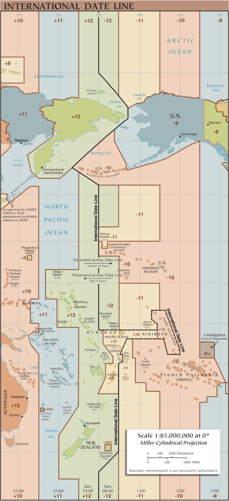
This means that a new day starts in UTC+12 and ends in UTC-12. The boundary between these 2 zones is called the date boundary.

Political time zones
In addition to the logical time zones that follow the earth’s meridians, UTC defines time zones adapted to the countries’ needs. I call these time zones political time zones because it is up to each country to decide which zone should apply in that country. These time zones have names and an abbreviation and indicate how much the time differs from UTC±0. In these time zones, time may differ by parts of an hour (minutes). An example of this being political is that in Sweden there are proposals that the summer time zone should apply throughout the year, ie we would end up in the same time zone as Finland.
Here are some examples of political time zones.
- ACDT – Australian Central Daylight Time, här är tiden UTC+10:30
- CET – Central European Time, här är tiden UTC+1:00
- CEST – Central European Summer Time, här är tiden UTC+2:00
- GMT – Greewich Mean Time, här är tiden samma som UTC
- AST – Atlantic Standard Time, här är tiden UTC-4:00
- PST – Pacific Standard Time, här är tiden UTC-8:00
International Date Line (IDL)
The boundary between time zones that have UTC+12 and UTC-12 is called the international dateline because it is a different date on the other side of the boundary. Because the countries around the date limit want to be on the same day throughout the country, it meanders forward and sometimes it goes all the way to UTC+11 or UTC-10. At Kiribati, the border runs the furthest east, and at Alaska furthest west. If you pass IDL, you must change the date. If you go west when you pass the IDL, you must increase the date by 1 day, if you pass in the other direction, you must decrease the date by 1 day.
Daylight Savings Time (DST)
As a further complication of the concept of time, summertime has been invented, which means that some countries have chosen to change the time zone during the summer. The time zone CEST is one such example and it is applied by some countries in Europe from 02:00 on the last Sunday in March to 03:00 on the last Sunday in October. In the spring, the clock changes from 02:00 to 03:00. The new time zone is ”before”, which means that the clock is more.
When the clock changes back to the normal time in the autumn, the new time zone is ”after”, which means that the clock changes from 03:00 to 02:00.
There is much more to read about time on the site timedate.com which has a lot of information for those who want to delve even further into the subject, such as GMT and UTC have slightly different positions of the 0 meridian. In UTC, the 0-meridian is based on modern calculations that have also taken into account that the earth is not a perfect sphere, which means that the 0-meridian is actually 102 m further east. You can check this with your smartphone if you visit the Greenwich Observatory.
Practical usage of time and position
We need to know both local time and UTC±0 time, sometimes what time it is in the time zone we are sailing to or have sailed from. When we sail, we also need to know where we are to be able to get where we want. We also need to position reported obstacles (eg fishing nets), so that we can avoid these.
SOS
If we were involved in an accident, we need to be able to send SOS with position and what time it is in UTC±0 when we were in that position. Wind and current mean that the boat always moves and then those who are looking for us can calculate our position (approximation).
Tides
Time is needed to calculate the tide, which changes depth and creates currents in coastal areas close oceans. Just the time in tide tables can be tricky to get right when using a computer or plotter to calculate the tide. What time does the program use in the presented tide table?
UTC±0, or the time set in computer/plotter? Same thing with tide tables on a website?
Weather
The time is also important to know when looking at a weather forecast. Weather forecasts with global coverage (eg GFS, ECMWF) are based on the clock in time zone UTC±0. Local weather institutes use local time (eg SMHI, DMI) in their forecasts.
Office times
If we are going to call someone in another time zone, we need to know the time difference so that we call when, for example, a marina is or a customs office is open
Up next
Finally, it’s time to sail back to Europe and it looks like it will be a good weather window for that in early May.

Du måste vara inloggad för att kunna skicka en kommentar.